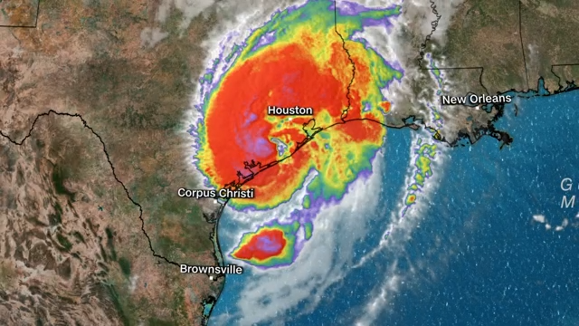
Western Harris County, Houston and the city’s closest western suburbs, including Sugar Land, Katy and Cypress, were in Beryl’s path after the storm came ashore Monday morning in Matagorda as a low-grade hurricane, according to the latest forecast track from the National Hurricane Center.
The rotating center of Beryl made a morning landfall at 4 a.m. Monday, but the storm’s outer bands of rain clouds had started harassing the Texas Gulf Coast on Sunday.

Where is Beryl now?
As of 7 a.m. Monday, Beryl was pressing inland from the Texas Gulf Coast, about 40 miles southwest of Houston, with maximum sustained winds of 75 mph as a low-end Category 1 hurricane. The storm was northeast of Bay City heading north at 12 mph.
After becoming as strong as a Category 5 hurricane in the Caribbean Sea last week, Beryl became a substantially weaker tropical storm after a July 5 transit across the Yucatan Peninsula in southern Mexico. Beryl spent the past weekend reorganizing itself into a hurricane on its north-northwesterly course toward Texas at 10 to 12 mph through the warm waters of the Gulf of Mexico.
TEXAS STORM TRACKER: Keep an eye on tropical storms and hurricanes as they approach the Lone Star State

What areas are on alert in Texas?
Rainfall: “Heavy rainfall of 5 to 10 inches with localized amounts of 15 inches is expected across portions of the middle and upper Texas Gulf Coast and eastern Texas beginning today through Monday night,” the hurricane center said Monday. “This rainfall will produce areas of flash and urban flooding, some of which may be locally considerable.”
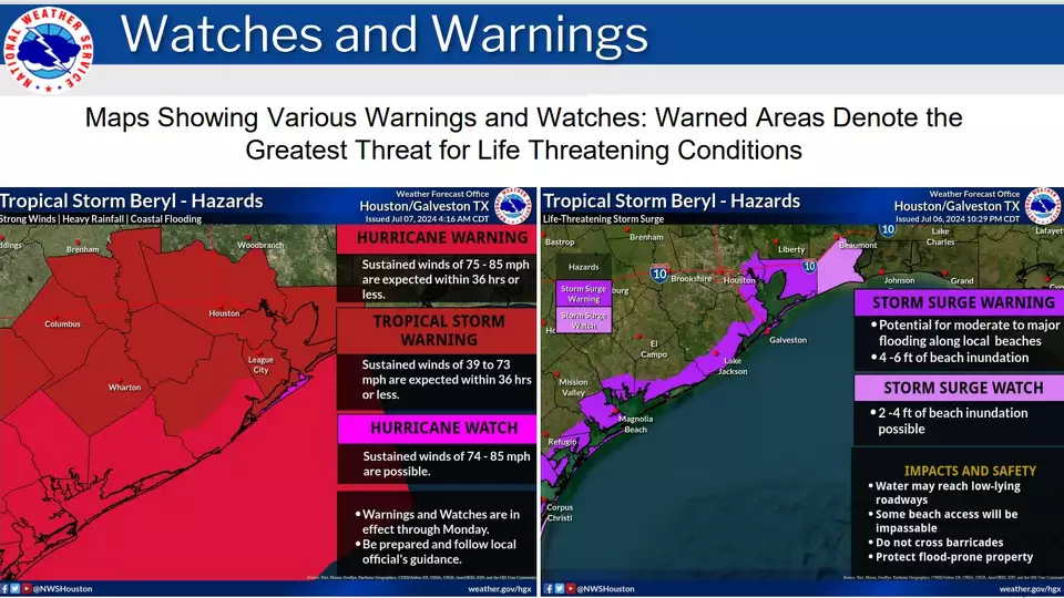
Harris County and several other suburban Houston counties along and west of Interstate 45 were placed under a flood watch Sunday through early Tuesday by the National Weather Service office overseeing Houston and Galveston.
Winds: A stretch of the Texas Gulf Coast, from Mesquite Bay northward to Port Bolivar, is under a hurricane warning issued by the National Weather Service. A hurricane warning, typically issued 36 hours before the arrival of tropical storm-force winds, means that hurricane conditions are expected within the warning area. “Preparations to protect life and property should be rushed to completion,” forecasters said.
WHAT TO EXPECT IN HOUSTON: Here’s what a Beryl landfall near Matagorda Bay means for Houston
A tropical storm warning, which means tropical storm conditions are expected within 36 hours, was in effect for the Texas coast from north of Port Bolivar to Sabine Pass.
Storm surge: A storm surge warning also was in effect for the Texas coast from Mesquite Bay to Sabine Pass, an area that includes Matagorda Bay and Galveston Bay. The weather service said storm surge warning indicates the possibility of life-threatening flooding from rising coastal waters moving inland in the next 36 hours.
Storm surges of 4 to 7 feet were possible in some areas, as storm winds combined with tidal flooding along the Texas coastline, forecasters said.
Where will Beryl go after landfall?
The hurricane center’s latest projections show Beryl quickly weakening again after making a Monday morning landfall, with the center of the storm near Matagorda Bay. As the storm moves inland, it will lose the heat energy and atmospheric moisture provided by the open ocean, which had fueled its once-explosive growth.
Beryl has remained a hurricane over Southeast Texas, at least four hours since landfall, but forecasters think it will eventually devolve again into a tropical storm as the center of the system takes a northerly course and tours the western Houston suburbs all day Monday.
The center of Beryl is expected to continue north, approaching Sugar Land after daybreak before crossing Interstate 10 just east of Katy. It will then north for several hours toward Cypress, then approach Conroe around 1 p.m. As a tropical storm, Beryl would then bank northeast and cross Interstate 45 near Huntsville before getting near Crockett around 7 p.m., all the while dumping rain across Southeast Texas.
Overnight into Tuesday, the storm would reach Longview and Marshall in East Texas by 1 a.m. Tuesday. By dawn on Tuesday, Beryl is expected to become an even weaker tropical depression, drifting northeast into Arkansas.


